A few years ago, I was driving an art director around on a scout when he asked me to take him to a gritty section of New York. Not exactly sure what to do, I drove him to a neighborhood with one of the highest crime rates in the city. He stepped out of the car, looked around, and said, “This isn’t right – this is beautiful! Where are the flaming barrels? The abandoned buildings? The gritty New York City?”
The only place you’ll find gritty New York City these days is in the movies.
William Friedkin’s The French Connection depicts just the kind of New York he was looking for. Made in 1971, the city’s decay is front and center in nearly every frame, from abandoned, grime-covered buildings and derelict cars to crumbling warehouses and trash-strewn lots, and at times, the neglect is nothing short of tragic. Yet New York’s beautification over the past 25 years has come at a price. Gone are many of the classic New York establishments and mom-and-pop stores of the past, replaced by a blandness typically reserved for suburban malls.
Let’s take a look at what has changed over the past 43 years.
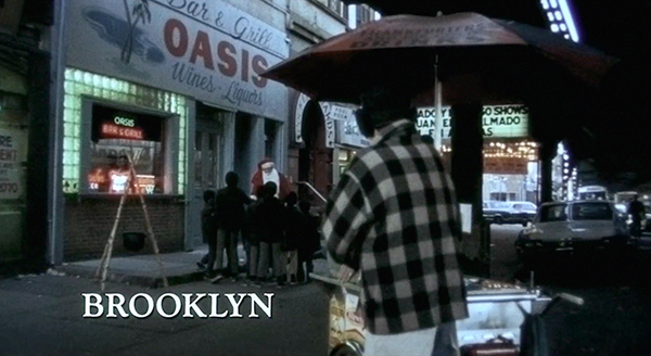
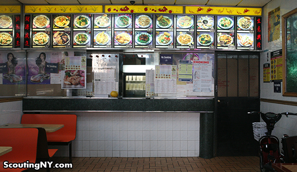
After a brief opening scene in Marseille (soon to be covered by sister site Scouting France), the action moves to Brooklyn, where we meet our hero, Jimmy “Popeye” Doyle, in front of the Oasis Bar & Grill. Shot at 914 Broadway on the Bushwick/Bed-Stuy border, the bar today is a Chinese Restaurant called China City:
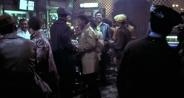
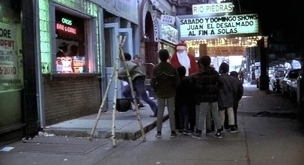
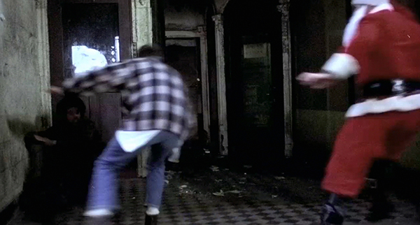
Popeye and his partner Buddy “Cloudy” Russo are engaged in a drug stakeout at the Oasis…
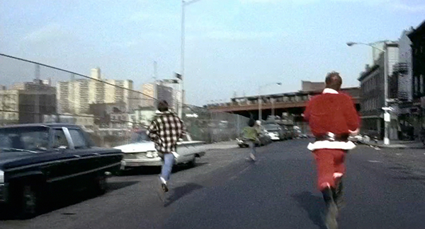
As Popeye, dressed in a Santa suit, entertains the local kids outside, Cloudy chases a suspect out of the bar. Note the theater in the background, known in 1971 as the Rio Piedras, and the pool hall beside it.
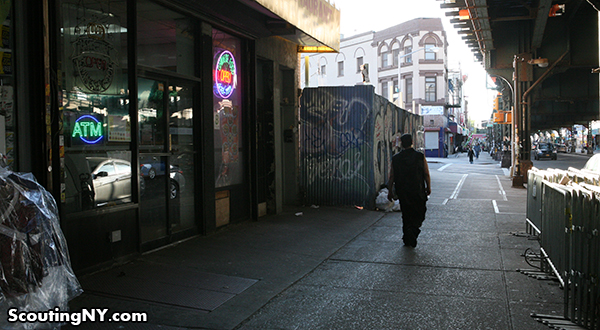
All gone:
This was originally the Loew’s Broadway, built in 1904 with seating for 2,000. Here’s a picture taken in its heyday, courtesy of CinemaTreasures.org.
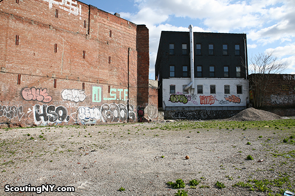
The theater was torn down in 1988, and the site has been a vacant lot ever since.
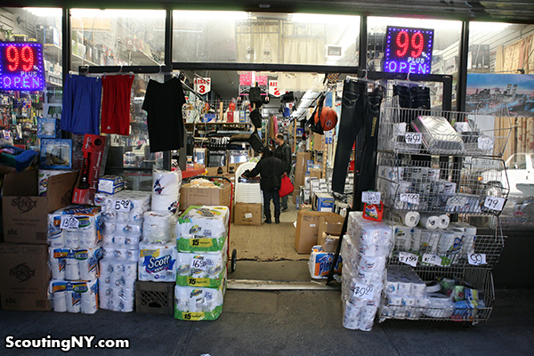
Popeye and Cloudy chase the perp into an unusual entranceway two buildings down:
Today, that facade is looking quite different as Senior Loco’s Bargain Bazaar:
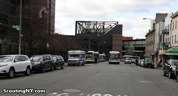
The chase jumps to nearby Bushwick Avenue and Arion Place as the dealer flees:
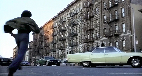
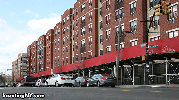
Then, going a bit wonky with the geography, the chase continues on Marcus Garvey Boulevard at Ellery Street:
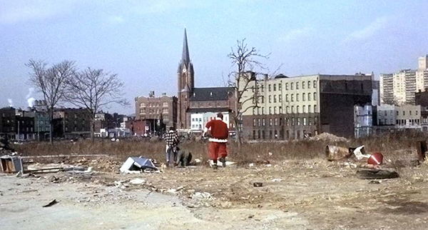
Popeye and Cloudy finally apprehend the suspect in an enormous vacant lot…
…which today, is occupied by Woodhall Hospital, built about 10 years later in 1982.
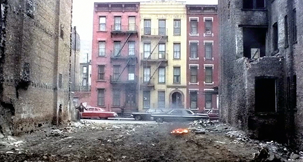
Popeye and Cloudy drag the suspect to a vacant lot, and through movie magic, suddenly wind up in in East Harlem. Does anyone recognize this street? Those three buildings are surprisingly distinct – 4-stories, 3-windows wide, an arched entrance on one of them. Then again, they might’ve all been torn down decades ago. I did a lot of searching, but came up empty.
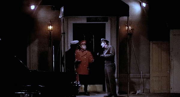
Later while getting drinks at the Copacabana, Popeye and Cloudy notice something unusual: a young couple, the Bocas, dining with noted mob figures. This was not actually shot at the Copa, and I wasn’t able to identify the stand-in location.
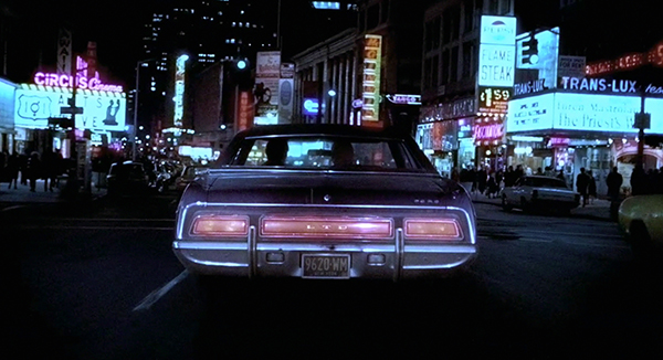
On a hunch, Popeye and Cloudy decide to tail the couple, driving through Times Square on Broadway. Note the Circus Cinema on the left, the Trans-Lux theater on the right (playing the 1970 Italian film The Priest’s Wife), and a restaurant offering a flame steak for $1.59.
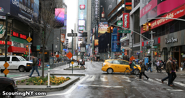
Today, we’ve got a Sbarro’s, the Hersheys Store, and a souvenir shop:
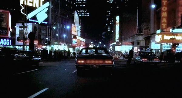
They continue south into Times Square. Note the famous Times Square Automat on the right, which opened in 1912 and offered pre-cooked food from coin-operated windows:
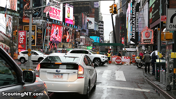
Today, it’s a Radioshack (although not for much longer?):
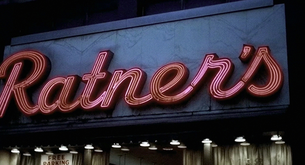
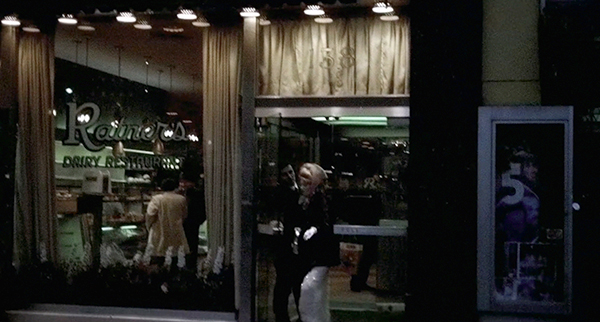
The detectives wait outside as the couple dines at Ratner’s, a famous Kosher dairy restaurant on Delancey Street on the Lower East Side.
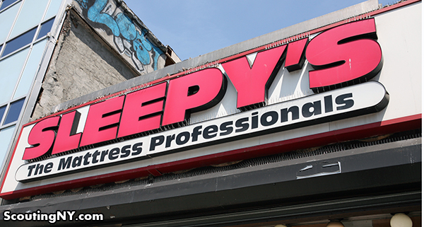
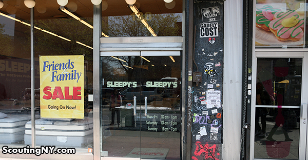
Today, it’s a Sleepy’s.
Originally opened in 1918, Ratner’s was known for its non-meat menu choices like gefilte fish, latkes, and blintzes. It closed in 2004.
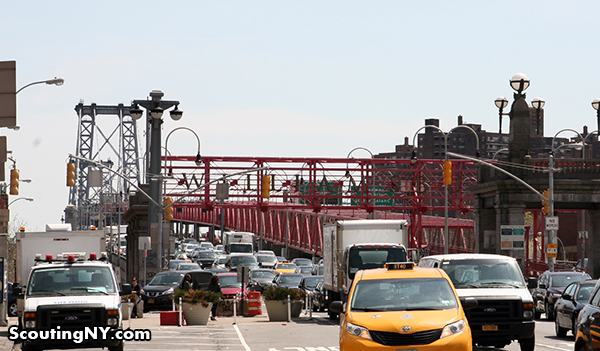
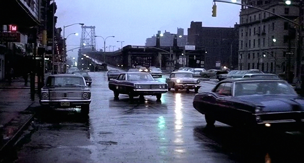
As the detectives wait for the Bocas to leave, we get a nice shot of the Williamsburg Bridge further down – note the changes made in its late 1990s redesign:
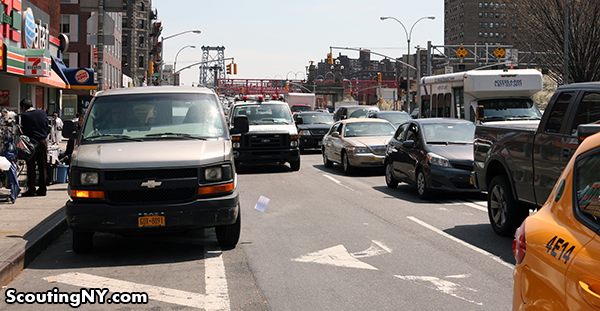
Finishing their breakfast, the Bocas take off, with Popeye and Cloudy in tow. Curious what that building was on the far right, now gone. Also, you can see a small sliver of the awning to the Loew’s Delancey Theater on the left, now sadly gutted (but we’ve got a 7-11, an AT&T store, and a Burger King!).
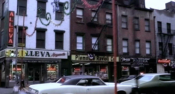
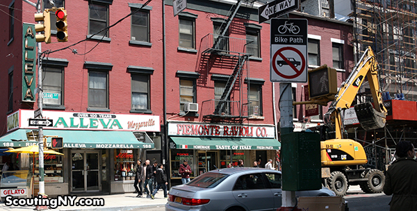
As the detectives drive through Little Italy, we get some street shots that, incredibly, are more or less unchanged over 40 years later. First, we cruise down Grand Street, passing the Alleva dairy, founded in 1892, and the Piemonte Ravioli Co., founded in 1920. Still there!
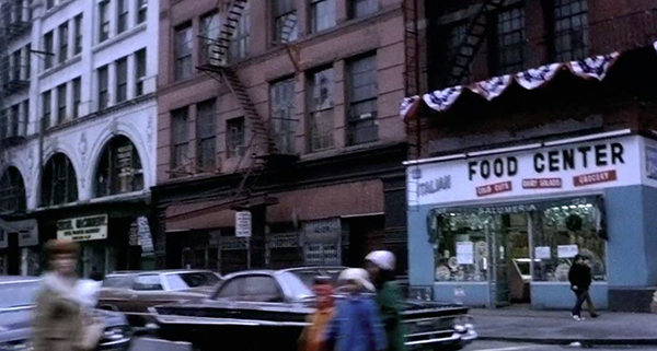
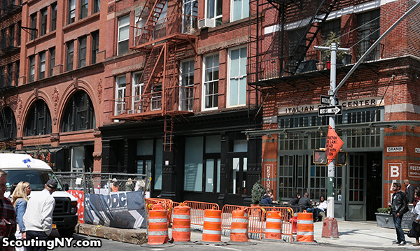
Further west on Grand Street, we see the Italian Food Center. The grocery store is now gone, replaced by an Italian restaurant going by that name. Note the refurbishment of the adjacent buildings:
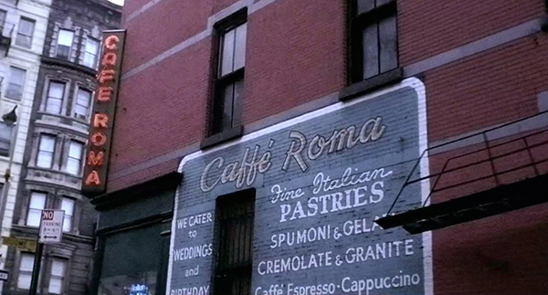
We get one final passing shot of Cafe Roma on Broome Street, founded in 1891 and still in business, complete with neon sign and painted wall ad:
The French Connection locations tour continues! Click here to go to the next page!









Great, great series. The interruption of Middagh Street in Brooklyn Heights happened about 10 years ago. An overheight tractor-trailer on the BQE hit the overpass with such force that it was impractical to restore the bridge to a spec that would support traffic. The city closed the Middagh Street bridge and put up the barriers and the green space. The side benefit is that the closure is that traffic exiting the Brooklyn Bridge could no longer use Brooklyn Heights as a shortcut to get to Columbia Heights and the southbound BQE; now, all that traffic has to go down Cadman Plaza/Old Fulton Street.
I can’t recall Middagh Street every being “a bridge”. It’s on solid ground, though the expressway may well be tunneled under it. My understanding is that the street was closed off for the express reason you mentioned, which was to alleviate all the “cut-through” traffic in that area. The best evidence that there was never a “bridge” there is the film itself.
This is fantastic. 1970″s NYC still exists. You have to look for it, of course. I live in it. Just take a ride to 191st on the 1 train, and take the Broadway (not St. Nicholas) exist. That tunnel, complete with 1970’s lighting, sends you right back. Talk about gritty urban squalor.
That subway station with the strangely placed entrance looks to me like the BQ platform at Brighton.
I was thinking the same thing as @slava, that the elevated entrance looks like it’s from along Brighton Beach Ave.
Great post! I love driving along 86th–the film comes to mind every time.
The el along Brighton Beach Avenue is 4 tracks wide and has support columns in the middle of the street as well as on the sidewalks. I’m thinking the scene was shot somewhere on Broadway in Brooklyn.
It looks a little like the F train station at Avenue I. I know there are some mid-street entrances there.
You’re right, Kevin. That’s East New York, near the LIRR station under Atlantic Avenue.
What constitutes “a strangely placed entrance”? None of this was shot on the Brighton line; it was all shot on the West End line. At the time, it was the route of the B-train, but today, the route has swapped titles with the Brighton line, and is now the D-train.
A few days after seeing The French Connection in a theater, I was asked to pick up my mother at my aunt’s apartment in Coney Island. I parked my car and started walking towards a nondescript building among a number of similar buildings. Something struck me as familiar, even though I had never been there before. Then it hit me: The scene where a sniper is shooting from the roof of an apartment building had to have been filmed there! In a couple of minutes I was up in my aunt’s apartment and I asked her about the film. Sure enough, months earlier there had been a film crew up on the roof and, since my aunt lived on the top floor, she heard all the racket they were making. I was somewhat amazed. But, now, I don’t look twice at all the filming going on around NYC.
As Scout points out in his amazingly thorough report, my aunt’s apartment was part of the Marlboro Housing Projects at Stillwell Avenue and Avenue W in Gravesend, Brooklyn (not in Coney Island, as I referred to it.)
Also, in another section, Scout refers to the modern Manhattan office building at East 40th Street and Park Avenue — 101 Park Avenue. I happen to work in that building, which has it own rich TV and film location history.
Brilliant!!!, I love this movie even more!
Awesome series! Well done, and thanks!
One tiny typo I noticed on the final page: “Boca leaves the car on Peck Slip” should say “Boca leaves the car on Dover Street”.
Amazing! Thanks so much for researching and putting this together.
I lived in Coney Island during the 60’s and 70’s.
I really enjoy looking at all the little mom and pop sketchy businesses in Manhattan that have disappeared. I never realized at the time that places like Ratners would someday be gone.
It’s a very different city now. It was inevitable, I suppose.
NYC is more accessible and livable for many people today, if they have money. This was the era when people with modest means could find a home here.
Is some aspect of the Ratner’s sign still lurking beneath that Sleepy’s sign?
I miss the old NYC. Yeah, it was dirty and decrepit, but damn if it didn’t have a ton of character. Not to mention the architecture! On page one, where you’ve got that row of nicely decorated apartment buildings replaced by flat, bland condos is a testament to how far we’ve fallen in what is “pleasing” to the eye. Maybe if newer architecture had any of the imagination of the classic I’d like it a bit more, but as it is I’m tired of the boring and sterile.
You did an unbelievable job tracing all the stills from the movie to their present day scenes! Bravo! I remember how frightening that scene of the near miss with the baby carriage was when I first saw the movie years ago.
For the subway station, you might also try the F line stretch running down McDonald Avenue. I agree, it looks like Brooklyn.
Yep. In fact, I’d wager that the shot is of the northern entrance to the Ditmas Av station on McDonald between Cortelyou and Ditmas. The giveaway is the stub track overhead, which once connected to the Culver Viaduct that ran up 37th street to the D at 9th Av.
Ian, You would LOSE the bet. It was on the old West End Line of the BMT, it became the B Line. It was at 61st. Street and New Utrecht Ave. and as a prior person wrote it connected with the Sea Beach Line Later the N Line, Which was below the street level,and also underground as part of the Subway system.
My parents haven’t been to NYC since the 70’s and I’m fairly sure it’s because they remember it exactly like this and they’re a bit scared. The grittiness that the city has lost in the last 50 years is really startling when seen in this context. Incredible job!
I grew up in Brooklyn and moved to California in 1971, where I saw the French Connection. I thought the el station where Popeye shot the assassin looked familiar. I grew not far from there. I remember you could walk down the stairs of the station and transfer to the N train. I would ride the N train two stations to Fort Hamilton Parkway, which was right around the corner from my apartment building.
One part of old NYC that seems to be dying fast, if not gone completely — candy stores. They were the neighborhood hang out.
The ad for a $1.59 steak was the actual name of the restaurant. The name was Flame Steak and you got a baked potato and vegetables for another $1…it was the BOMB and they were all around the city…I think the chain either vanished or it became Tad’s steaks.
Wish they were still around:(
This blog link has French Connection location info http://www.the-movie-portal.com/the-french-connection-1971/ Seems to say the East Harlem location is an empty lot by 114th St and Pleasant (but i couldn’t find the buildings) and Roy’s Bar by the El is possibly by Myrtle Station (Myrtle and Broadway), since demolished.
I was sure there was a post about the three buildings awhile back on Curbed but I can’t find it. I think the fire escapes are gone but I can’t remember the historical significance of the buildings or any other details about the post. Sorry not a lot to go on but maybe this will help someone else figure it out.
Sonny Grosso said on at least a couple of occasions where the Santa Claus interrogation scene was filmed. My recollection is it’s either 112th or 114th St. between 2nd and 3rd Avenues.
The producers could not get permission to shoot interiors in the real Copacabana so they substituted a club that was on E55th St. near Lexington Avenue. Nobody I’ve talked to can seem to remember the name of the club. Although it’s called “the Chez” in the film, it’s real name was something else. It was owned by a Greek millionaire (who shakes Popeye’s hand at the beginning of the scene), and the entire building was destroyed in a fire in the 1980’s, according to Sonny.
The raid takes place at Roy’s Bar, which as you wrote, is either on Myrtle Ave. or Broadway. The bowling alley, which I think is called the Duplex, is another clue. If somebody can locate a 1970 Brooklyn phone directory that should settle the affair once and for all.
The club was called: “The Pembles Club”, was originally in the 56th Street East. (in the film “The Chez”). The owner was Peter Van Arthos.
You’re missing two key locations from the film. The auto graveyard scene was shot in Hunt’s Point in the Bronx, and the Police impound garage where the Lincoln was taken apart is on 56th Road in Sunnyside, Queens.
In the second Delancey St. wide-view photo, the building at lower right was the old 7th Precinct on Clinton St. It was next to the Apollo movie theater. I remember that theater fondly, my father took the family to the movies on weekends.
Thanks for the post. Nice flashbacks.
OK, consulted a 1970 Brooklyn telephone directory at the Public Library. And there it is listed plain as day: Roy’s Bar, 1182 Myrtle Avenue (same address as Duplex Lanes). This address is actually on the north side of the Myrtle Avenue/Broadway junction, where trains no longer run.
Actually, I meant its located at the “south” side of the Broadway/Myrtle Ave. junction.
The location of Roy’s Bar makes sense in the context of shooting locations since the production company was nearby for the stuff with Sal’s diner. But what doesn’t make sense is that if Roy’s Bar was in fact on the south side of Myrtle somewhere between Bushwick and Broadway, then when the camera swings around to show the actors enter the bar, shouldn’t we be able to see the Broadway J/Z elevated tracks in the distance? All I can see is open sky.
Unless I am misunderstanding where the bar was.
Hey Scout, great post Then and Now post as usual. You were wondering who was smart enough to buy that For Sale building on Water Steet on page 5? I’m pretty sure it was Frank J. Sciame, who bought the charred hulk of 273 Water Street for a dollar and refurbished it into luxury apartments. That building is the Captain Rose House, the third-oldest building in Manhattan and the site of Kit Burns’ Rat Pit, a waterfront dive with an ampitheater for dog and ratbaiting fights. You can read more about it here if you want – http://fortamsterdam.blog.com/2014/04/17/kit-burns-rat-pit-at-273-water-street/
Seeing the italian food center brought back memories. had many a great sandwich there in the 80s….so sorry to see it is no more.
Just FYI..Gritty..Recent trip to Bklyn from CA — Atlantic Ave to downtown Bklyn does not look gentrified or upscaled, not to mention “mall like”..I’ll bet you can film 2 dozen gritty films if you put your mind to it….hey, just sayin
Wonderful job.
The one thing you missed is that the subway/car chase is not a “very” accurate trip through South Brooklyn as late parts of the chase inexplicably switch to following the Myrtle Ave El in Ridgewood, AKA Southwestern Queens. It starts when Popeye loses control of the car and slams sideways into a fence after avoiding a truck. This fence, on Onderdonk Ave between Palmetto and Woodbine Streets, closes off the old street level right of way the trains used to use before the EL was built above it in 1915. It then was used by trolleys until they were removed in 1948, and is now under consideration by the MTA as a off street busway. The gate was only recently replaced with a nicer driveway gate by whoever leases the alley from Transit. He then turns up Woodbine Street which, at least today, is a one way down street. As he’s turning you can see St. Aloysius Roman Catholic Church in the distance.
Then, after the conductor gets shot, Popeye is pacing the train on Putnam Ave on the section between Fresh Pond Road and Forest Ave. The El at this point is over it’s alleyway, which a car can’t drive down that fast as it was mostly dirt then and parts still are today. He then turns onto left onto Forest Ave, passing under the Forest Ave Station and the right to rejoin the other section of Putnam.
It’s just a small bias of mine since I live in Ridgewood, and don’t like that Bensonhurst gets all the credit for what is often called the greatest car chase in movie history when it didn’t do all the “work”. My mother actually saw part of this being filmed as the neighborhood was abuzz that Gene Hackman was around.
It’s funny, James, but the corridor between Broadway in Bed-Stuy and 58th Road in Maspeth is where much of THE FRENCH CONNECTION was filmed. From the Santa Claus chase around Bushwick Ave. to Sal and Angie’s luncheonette on Wyckoff Ave. to the part of the chase on Palmetto and Onderdonk you cited and finally the Police garage in Queens.
Yea that chase scene jumps around a whole lot. It even goes down one avenue one way and then back down the other way in one consecutive scene lol. Movie goers would never even notice that unless you lived there. But the beginning of some of the chase was in Bensonhurst so I think a number of neighborhoods can claim a piece of that famous chase. It passed my high school twice (Lafayette right between Stillwell Ave and 27th Avenue and the park I use to hang out in as a kid on West 13th Street, right off the Marlboro Housing projects were Popeye lived. I actually watched them filming that scene. Cameras were mounted on some specially rigged vehicle and they drove down West 13 Street filming the car through the vantage point of the park being in between. Then the chase jumped all around into other neighborhoods and never returned. They also had an N train when it should have been the B line at that time at least during the scene under that particular El (as we call it in Brooklyn).
Great 70’s movie. Always liked Hackman.
I think the subway stop is the Kings Highway F. https://www.google.com/maps/@40.602026,-73.972527,3a,37.5y,341.27h,84.9t/data=!3m4!1e1!3m2!1skzy1KAiAXpiys4f7xGl9iQ!2e0
I was going to say Avenue I but I think you’re right.
What an amazing post!! I love this site so much! If I were a rich person, your movie would be made!!
Beautifully done
You put in a lot of work to make this as amazing as it is !!!
This was a delight…what a great, fun piece of scholarship! I am thinking of searching for 70s grit in Newark.
Hey Scout,
I noticed something in your photo of Ratners / Sleepy’s. It looks like there are old remnants of the old neon sign behind the Sleepy’s sign. I made a gif to illustrate where you can see the supposed bottom parts of the sign still.
http://makeagif.com/i/zJEa_y
When I lived on Arion Place a few years ago, Ridley Scott’s team came in to that same stretch of Broadway to shoot scenes for American Gangster. I always wondered how many people in the crew knew that French Connection had filmed on the same location.
Hey Nick, This is Tony Lo Bianco. We had such a great time filming the movie back then and now seeing all the locations present day brings back wonderful memories not only shooting the movie but showing off New York as THE place to shoot movies.
Keep up the great work.
All my best,
Tony Lo Bianco
Tony, you’ve had a long and great film career and it was very nice of you to comment here. I had always thought that you dropped the Lincoln off at night in Brooklyn, but I learned here that it was on Dover Street in Manhattan. Can you comment further about “Angie” (Arlene Farber) or any of the other actors from the French Connection?
Outstanding! Absolutely outstanding.
I would like to donate, but can’t promise at the moment.
I’m going to watch the film again…in a few minute, right after I make an Egg Cream w/extra seltzer
You do great work!
Just to give these “now and then” pictures a little more perspective, you should know that the FRENCH CONNECTION was filmed between late November 1970–mid-March 1971. It was a winter film shoot, and I believe it was extremely cold that season.
You can see some Christmas decorations in the hotels, and Popeye’s Christmas “celebration” with the children.
And then the Valentine’s Day decorations in the store window.
“Boca leaves the car on Peck Slip around the corner. Note how the cinderblocked building on the right has been completely restored (though why remove the fire escapes?):”
In the caption above that corresponds with the photo of the Lincoln, the street name is wrong. It should be Dover Street (between Water St. & Front St.), not Peck Slip. The Flickr site that is the source for the photo —
https://www.flickr.com/photos/scoutingny/14131534571 — has the street correctly identified.
I don’t think “gritty” is the right word for the city depicted in the French Connection. As I look at the city in the movie, I’m amazed by how clean and safe and functional it looks. Other than a few abandoned buildings and one homeless guy sleeping in a doorway in one shot, there’s no hint of what it was to become.
There’s no graffiti anywhere, not in the housing project, not on the subways, not on the sides of the buildings adjoining the vacant lot. There’s far more sign of vandalism in the shots of that Nick took last year.
The New York of the French Connection is much closer to “New York, 1955” than “New York, 1981,” the one where every surface in the subway and projects would be covered in graffiti and very much the property of people who feared neither cop nor tie-wearing French assassin.
I’d say the big difference is the almost utter lack of anything corporate. The New York of the French Connection is unbelievably Mom-and-Pop. There are very few chain stores visible anywhere, although Popeye does walk past a “Godiva” at one point, which surprised me, because I would have bet that brand didn’t exist in 1971. It’s definitely a very different city, but it’s not a gritty city.
I saw the sign on Palmetto Street close to Cypress Ave say filming Gotham tv Series on Feb 24, Feb25 at this location under the M train
Any shots filmed in Astoria? I grew up there and thought there was some.
The old building on Delancey st. you were curious about was the old NYPD 7th Precinct
I happened to catch the movie American Gangster (with Denzel Washington) and afterwards remembered the French Connection was streaming so I watched that one too. Then I found your site browsing for some of the original locations and realized that the new China City restaurant (formerly the Oasis Bar from TFC) was used in a major scene in American Gangster where the character played by Washington stops to get food for he and his wife and an attempt is made on their lives. It is at about 2:02 into the Gangster movie there are extensive exterior shots and a few of the inside of he restaurant as well.
This is so good. I have recently become disenchanted with NY and this shows exactly why. I loved the grit that no longer exists. I agree with you about the custard shop in GCT… but then I thought about how gross it is under ground and would I really want to get some unwrapped prepared food? probably not, haha. Also hate that there are no more car piles under the Brooklyn Bridge. What a gyp!
When you’re in the motormans booth with the assassin, he’s riding the old M line in Ridgewood. The train crashes btwn the Fresh Pond Rd Station and Metroplolitan Ave.
Great site. I wonder however, if the images themselves convey a lack of grittiness due to the changes in the technology. I am wondering if the today’s photos were done on a somewhat modern digital camera while the film was on … film. In fact the cinematographer probably chose times, and film stock, and structured his shots to accentuate the “grittiness.” I notice that most of the Manhattan shots were often devoid of shadow while your shots were often bright sunlight.
For example, take a look at the shots on page 4 in front of the Westbury Hotel. I wonder how that shot today would look on tungsten film shot in the late fall afternoon of a cloudy day. I guess you can simulate that with some digital trickery, but a cheap old 35mm camera with an worn out lens might give the best results.
Does anyone know what type of factory the final shootout took place? I believe it was on Wards Island. Been driving me nuts
Upon further investigation, I found an old map of Randall’s island in a document called “Historical Perspectives” which is an archaeological documentary study of the shoreline of Randall’s Island. In that document lies an old Key Map of the island which shows the layout of the old reform school on the southern tip of the island near Ward’s Island. One of the buildings labeled #60, was apparently a bake shop/kitchen. I suspect this was the building with the ovens where Gene and Roy search for Frog 1 and end up shooting Muldrig. any other thoughts will be appreciated.
where did they stake out the Lincoln at night?
Great work btw
Exceptional research and creativity, Nick! I’m astounded at your accurate and jaw-droppingly detailed work.
It appears to have been full of some kind of ovens. The building, now gone, was next to another building connected to a large smokestack, both extant. The oven or furnace fronts are not constructed as crematory retorts are built, nor would they appear to be efficiently charged as incinerators. Nor does the construction appear to be that of boilers. They MIGHT have been used as heaters in some kind of smithing or metalworking operation. I’m still looking to find the answer. If you find out, let us know!
NYC was plenty dirty and gritty back then, with trash in the gutters and on sidewalks, but the graffiti craze had not taken hold yet, and there were no plastic bottles and styrofoam containers everywhere, as there are now. I spent many weekends in the city around 1970-72 and remember the sights and smells very well. The construction boom which came later, in the 1980s, changed the look of the city significantly.
The address for the bar Cloudy and Popeye raids is 1128 Myrtle Ave. in Brooklyn. It was near the corner of Myrtle and Broadway. It’s a Checkers now. Back then it was Roy’s Bar next to Duplex Bowling operated by Duplex Lane Inc. The beginning of the scene starts with Cloudy and Popeye walking from a bus at 950 Broadway to the bar on 1128 Myrtle, right at the stairs going up to the train station. In the movie it looks like one straight street but it’s actually a corner.
The final scene in The French Connection was shot in the remains of the Randall’s Island Bakery. I haven’t been able to find anything more on the bakery itself or what company operated it. If anybody knows anything about the history or at least when it was in operation, please, any information would be appreciated.